.jpg)


.jpg)


/origin-imgresizer.tntsports.io/2026/01/11/image-e0142c20-61a4-495b-a1c4-a9e1cf7eeecb-85-2560-1440.jpeg)


:format(webp)/cdn.vox-cdn.com/uploads/chorus_image/image/66321622/1206682849.jpg.0.jpg)


:format(webp)/cdn.vox-cdn.com/uploads/chorus_image/image/67131045/1261725039.jpg.0.jpg)


/origin-imgresizer.eurosport.com/2024/02/04/3880159-78836108-2560-1440.jpg)


Journey through Pakistan on the Karakoram Highway

A journey along the Karakoram Highway in Pakistan is about far more than getting from A to B. As you drive, it feels like a cinematic movie you can’t tear your eyes away from. Outside your window, formidable pyramids of rock rise over 7,000m (23,000 ft) into the sky, black and white glaciers slice through the landscape, and rivers rage below.
There’s a high chance the Karakoram Highway makes up a part of your Pakistan adventures, so here’s everything you need to know about this culturally and politically significant road connecting Pakistan to China.
What is the Karakoram Highway in Pakistan?
The Karakoram Highway has many names, including KKH, N-35, and the China–Pakistan Friendship Highway. As one of the world's highest paved international roads, reaching incomprehensible heights of 4,714 m (15,466 ft) at the Khunjerab Pass, it’s also coined the ‘Eighth Wonder of the World’ — from the other-worldly landscapes that the highway passes through.
See it for yourself on: Pakistan: Lahore & Hiking the Karakoram Mountains

What’s the route of the Karakoram Highway?
Most people begin their Karakoram Highway adventure in Pakistan from the capital of Islamabad. However, the KKH officially starts one hour away in the town of Hasan Abdal in the Punjab province.
From Hasan Abdal, the highway winds its way through Pakistan to the Khunjerab Pass in Gilgit-Baltistan. Here, the road crosses into China, becoming the China National Highway 314, running through the Xinjiang Uyghur Autonomous Region.
How long is the Karakoram Highway?
The KKH stretches across Pakistan for a staggering 1,300km (810 mi), acting as a gateway to some of the country's best wonders, including Nanga Parbat, Passu Glacier, Khunjerab National Park, and Shigar Valley.
See it for yourself on: Pakistan: Hike the Karakoram Mountains
History of the Karakoram Highway
Once a leg of the ancient Silk Road, the KKH has always been a highway of some sort. Instead of cars, it was used by traders, pilgrims, and adventurers using human or horse power. This route was one of the world’s most important trading routes connecting Central Asia, China, and South Asia.
In 1959, Pakistan and China decided to take on a monumental feat of engineering and jointly build the Karakoram Highway, completed in 1979. During its construction, more than 24,000 Pakistani and Chinese workers braved the harsh terrain, extreme weather, and high altitudes to connect the two countries. Sadly, around 800 Pakistanis and 200 Chinese workers died in the process, mainly from landslides and falls.
The Karakoram Highway symbolizes a strong partnership between China and Pakistan, forming a critical part of the China-Pakistan Economic Corridor (CPEC). This road fosters trade, tourism, and cultural exchange between the two countries. What was once a strategic road is now a sought-after attraction for both international and domestic travellers wanting to snap photos at Khunjerab Pass. Along the way, you’ll spend time falling in love with the remarkable snow-capped giants of the Karakoram mountain range.
See it for yourself on: Pakistan: Karakoram Highway, Local Eats & Village Life

Don’t miss these highlights of the Karakoram Highway
You could easily spend weeks travelling the Karakoram Highway, with countless detours to explore cultural villages, world-famous hikes, and stunning glacial lakes along the way. Here are some must-see spots to include on your KKH itinerary:
Khunjerab pass
At an elevation of 4,693m (15,400 ft), Khunjerab Pass is the highest paved border crossing in the world, linking Pakistan’s Gilgit-Baltistan region with China’s Xinjiang province. No visit is complete without capturing a photo at the iconic Khunjerab Border Gate, a symbol of the strong ties between the two nations.
Nearby, Khunjerab National Park offers one of the best opportunities to spot Marco Polo sheep and elusive snow leopards in Pakistan — though a snow leopard sighting is rare and requires a fair bit of luck!
See it for yourself on: Pakistan: Karakoram Highway, Local Eats & Village Life

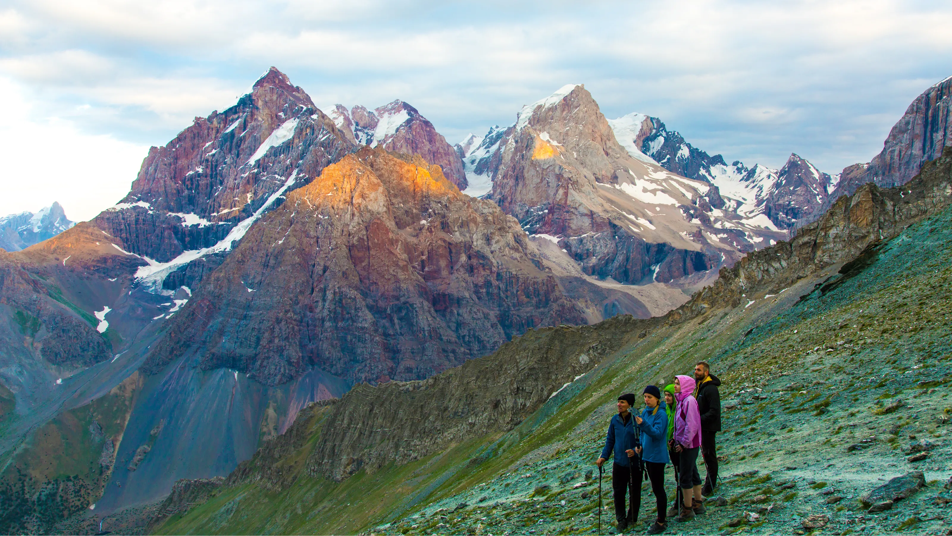
Hunza Valley
One of the country’s most popular tourist destinations, Hunza Valley is home to the Hunza River and stunning towns like Karimibad, famous for its gemstones, unique cuisine, and culture. Here, you’ll find the legendary Rakaposhi Mountain, visible from the KKH. Standing at an impressive 7,788m (25,550 ft), hiking to Rakapashi Base Camp is a popular trek in Pakistan.

Thallay Valley
The Thallay La Trail is one of the best hidden gem treks in Pakistan and once served as the only link between the ancient kingdoms of Khaplu and Shigar. Located in the outstanding Baltistan region, this challenging hike offers panoramic views and warm hospitality. Still largely untouched by mass tourism, the local people happily welcome travellers to discover and fall in love with their home.
See it for yourself on: Pakistan: Hike the Karakoram Mountains
Passu Glacier
Wedged between snow-capped peaks, Passu Glacier is a sea of jagged ice. Moving ever so slowly as if alive, the glacier loudly groans on its way to Hunza River. From above, it’s nothing short of phenomenal. Crossing it, as part of the Patundas Trek, fills you with respect for the power of Mother Nature.
See it for yourself on: Pakistan: Karakoram Highway, Local Eats & Village Life
Best time to visit the Karakoram Highway
Previously, the Karakoram Highway was closed from December to March due to weather making the road impassable. In an attempt to promote tourism and trade, Pakistan’s Frontier Works Organization (FWO) now works through the chilling winter months to keep the highway open.
While great news, it’s not really the best time to travel along the Karakoram Highway. Instead, take on this road between May and October. The chances of your journey being disrupted by severe weather or problems with the road like landslides, rockfalls and flooding are much lower. The late spring and summer months also offer the perfect opportunity to deviate from the highway and visit some incredible attractions along the way, like Hunza Valley, Attabad Lake, Khunjerab Pass, and Thallay Valley.
See it for yourself on: Pakistan: Hike the Karakoram Mountains

Is the Karakoram Highway safe?
The Karakoram Highway is generally considered safe, and as a route frequented by tourists, the government is committed to its security. Expect checkpoints and have your passport and visa handy. It also passes through some of the safest regions in Pakistan like Gilgit-Baltistan.
While the KKH is largely well-paved and maintained, it is a mountainous road with endless steep curves, narrow sections, and high altitudes. Ensure you’re in the hands of an experienced driver when tackling this road, especially one familiar with sections prone to landslides and rockfall.
Most people won’t notice they’ve reached heights above 4,000m (13,100 ft), but altitude sickness is possible. The effects are usually mild and subside as you descend, but be mindful of symptoms like nausea, headache, dizziness, and fatigue. Staying hydrated is key to preventing it.

Where to go trekking in Pakistan
The Karakoram Highway takes you to some of the best spots for trekking in Pakistan. Weaving its way through the Karakoram mountains, you’ll pass famous peaks like Nanga Parbat, Rakaposhi, Diran, Ultar Peak, and more — a fun way to pass the time is to try to be the first to spot them from your window.
Beyond the towering mountains, the highway also offers striking glaciers, lakes, and valleys, each hiding its own trekking opportunities. Notable spots include the Passu Glacier, the turquoise waters of Attabad Lake, Hunza Valley, and Thallay Valley.
See it for yourself on: Pakistan: Lahore & Hiking the Karakoram Mountains